| The Walled City of Radstadt |
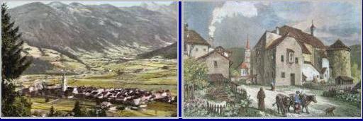
| Radstadt, at the foot of the Tauern mountains with the mighty Dachstein in the background, is first mentioned in 1074 and recognized as a town in 1289. It was the only mountain city in the Archbishopric of Salzburg, and it was a flourishing medieval trading center due to its strategically important position. In the Peasants' War of 1526, Michael Gaismair and his rebel forces seized the town and its vigorous defence was rewarded by Archbishop Matthaus Lang with the motto "Ever Loyal".The 13th century walls are of a symmetrical design and include three watch towers, Hexen, Teich and Kapuzinerturm, built between 1527 and 1535. The invading Turks once camped beneath these walls. It is called the "wheel city" because six routes radiate from the city center: Sparkassenpassage, Stöcklloch, Scheikstiege, Metzgerloch, Baderstiege and Friedhof, and there is the Millenniumspfad, a walking path along the walls, plus an old castle dating from 1298. The Kapuzinerturm tower watches over one of the key north-south routes. Musician and organist Paul Hofhaimer was born here in 1459 into a well-to-do family. In 1480, he was called to Innsbruck by Duke Sigmund to serve as court organist. Hofhaimer was granted a lifelong position there, but he also began serving Emperor Maximilian 1, who took over Tirol's legislature in 1490. In 1498, after several years of travel, much of it with the king, he moved to Passau, and then to Ausgsburg in 1507. Maximilian and the Polish King made him a nobleman, a knight and "First Organist to the Emperor" in 1515. Hofhaimer's last move was to Salzburg, where he remained as Cathedral organist until his death. He was not simply a performing musician, he was considered the finest organist of his age by many. He taught an entire generation of German organists and he influenced later Baroque music. He was one of the only German-speaking composers of the time with wide repute outside of Germany. The city of Radstadt, originally named Altenmarkt, is in the district of St. Johann in the heart of the Pongau in the province of Salzburg, and was settled by Bavarians in the 7th century and later Christianized. Radstadt was granted municipal rights, privileges, and freedoms in 1289 by the Archbishop of Hohenegg, freeing them for ten years from almost all taxes and duties. Ancient roads intersect nearby, connecting the eastern and western mountain areas by the road crossing the Radstädter Tauern mountain pass. It is bordered by the Taurach stream and Enns River and was used by the Romans. It separates the Pongau from the Lungau. Tauernhaus |
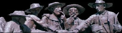
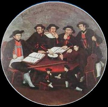
| The name Pongau first appears in documents in 750 and 788 as a particularly favorable terrace. Main grains grown by the settlers were oats and rye and even some hops later. They operated an exchange of goods and supplied salt to the south and brought wine, spices and cloth into the north. Early city and market municipalities were differentiated from villages in that authority for the regional law courts went to some while others only got market right awards. In 1525, there was a great exodus from the valley after the rebellion of the farmers and some miners, leading to farmer wars of 1525 and 1526. Radstadt was rewarded for its loyalty to the government. The highlanders, mostly poor farmers living in the Pongau and Pinzgau, lived an insular existence largely cut off from the goings on around Salzburg. Historically, those that had the occasion to travel to the Protestant cities brought back Lutheran books, and soon the hills were full of stubborn crypto- Protestants. All was well as long as they were left alone, but under Archbishop Firmian that was no longer be possible. The Evangelist farmers in Schwarzach began organizing in 1729, and delegates of the Pongau sent a delegation to Regensburg in 1731 for relief from the aggressive measures of the Church under Firmian. Their protest was stalled. The firmly united Lutheran farmers met secretly and determined that everyone should be permitted to freely exercise their religion and nobody should be forced from their property or their native country, and that they should be allowed to wait for a resolution from Regensburg; meanwhile they would have to live under the protection of the emperor. 150 Schwarzach farmers took an oath to obey “the rules of God more than mankind” by taking a lick of salt from their fingers and promising to live and die in the Lutheran faith. Called the Salzbund, they are often called the Saltlickers, portrayed above and at top of page. The leaders of the Salzbund included the smithy Stullebner of Hüttau who was known for his elegant sermons. Meanwhile, they were refused acknowledgement of baptisms, weddings, and funerals. They met again in August, 1731 with approximately 100 delegates from Radstadt, Wagrain, Abtenau, Gastein, Goldegg and Veit, and at the meeting they called for the “federal state parliament,” singing the 26th Psalm afterward. They formed a resolution to send another delegation to Regensburg and a further to Vienna to the emperor; again salt was licked and sworn with the oath, "God and the comrade loyalty into death, dipped into salt." In the end, under Firmian, those who professed themselves to the Lutheran religion departed. 4,850 people were expelled and most went to East Prussia, but a few ended up at Ebenezer, in America. Persecution of the Protestants was keen in Gastein in the most southern part of the Pongau. Jesuits fomented discord and spying within communities and even within families. Hans Mossegger, a Protestant lay preacher and leader from Wagrain who was exiled in 1732, once complained of the Jesuits: "No household, no bedroom, no barn or stall, no straw hut or pasture shack , no basement, no cave is safe from their spying. Like wolves and assassins, the Jesuit fathers creep into your houses and poke into every corner, questioning children and farmhands. If you say anything, you are lost." There is a famous story about an orphan boy named Balthasar Brandstaetter. The legend is that he was refused papers to emigrate with his exiled Protestant stepfather, Stephan Polsteiner, so he jumped out of the third floor window at the Wagrain Rathaus to escape, and not only miraculously survived, but followed his stepfather into exile, arriving in Augsburg, a destination for many Protestant exiles, in 1732. By some accounts, several retained boys escaped from the Jesuits and tried to find their banished parents. |
| The Pongau Protestants: The Salzbund |
| The Neighborhood and Specifically the Pongau; the Salzbund |
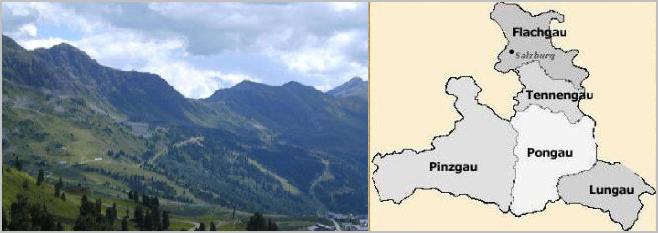
| Salzburg was divided into various sections (see map below). Lungau, full of green rolling pastures, steep mountain- sides, large basins and narrow valleys lies in the south-easternmost corner of Salzburg Land. The Lungau valley is enclosed to the north and to the east by the Niedere Tauern, to the south by the Nockberge and to the west by the Hohe Tauern. The two main valleys of the central basin are Taurachtal and Murtal, Taurachtal being the most fertile and densely populated of the Lungau. Its many other valleys form a fan shape. Among its minor valleys, Zederhaustal is the longest valley. Until recently, the Lungau was rather isolated. Flachgau is the most northerly part of Salzburg Land and contains mountains, meadows and hills, with forests, lakes, ponds and marshes. In the Ice Age, the masses of the Salzach glaciers formed "fingers" toward the north between Salzburg and Bavaria. The high Flyschberge (Flysch mountains) loom in the background. Several truly lovely lakes date to the Ice Age. Tennengau extends south from Salzburg, its western border dominated by the Göll massif while to the east, the Gschütt Pass leads towards Upper Austria. The river Salzach has dug through the chains of mountains Hagen and Tennengebirge over several thousands of years. The gorges carved by the river are called Salzachöfen are in places extremely deep. Pinzgau is the largest part of Salzburg Land, and subdivided into Mitterpinzgau, Unterpinzgau and Oberpinzgau (central, lower and upper). Central Pinzgau, between Tyrol and Bavaria, is shaped like a sharp prism and displays a varied mountain landscape. The Großglockner Hochalpenstraße (high alpine road) runs through its valleys and links to the highest mountain in Austria, the Großglockner, which does not lie on Salzburg Land territory but is nevertheless tied to it by this road. The Hohe Tauern forms the southern border of the Pinzgau. This are the longest and most inaccessible section of the central Alps and their summits are covered by glaciers. In Oberpinzgau, one steep, narrow valley stream tumbles after another down the Hohe Tauern chain. At a height of 3674 metres above sea level, the Großvenediger is the highest mountain in Salzburg Land. Pongau, south of Tennengau, is surrounded to the north by the rocky wall of Salzburg's High Alps, by the chain of mountains Hagen and Tennengebirge, only penetrated by the Salzach. To its south is the Hohe Tauern and the Radstädter Tauern, to the east the Dachstein mountain group and to the west the Steinernes Meer and the Hochkönig. There are several side valleys leading into the Salzach valley. Pongau has a huge icy world in the Tennengebirge, the biggest cave in the world accessible to visitors. The summit ridges of the Hohe Tauern and Niedere Tauern rise up over the Schieferberge in Pongau, traditional mountain farming regions abundant with forests and mountain pastures. Tremendous glacial ice streams cover the area with huge ice masses that back up at the mountains, then roll over it and reach the lakes of the salt chambers below. From 10,000 to 1800 BC hunting and fishing took place in the Pongau, and there were cavemen who bred cattle in the Bronze age. The dwarfed Char, a trout of the high Austrian mountain lakes are called Schwarzreiter, or Schwarzreuter (Black Rider).This name was created during the Counter-Reformation in the Salzberg area. Rebel Protestants had to retreat to the mountain areas, and many fled to the region of the "Gosau Lakes" in Upper Austria. The Archbishop of Salzburg sent out his henchmen on horseback, the so-called Black Riders, to capture them. The Riders had to cross over ice-covered Lake Gosau. However, the riders with their horses went through the thin ice and drowned in the lake and ever since, the local people have called the dwarf Chars of the Gosau Lakes, the Schwarzreiter. On the Einoedberg and Puergstein there were copper mines, and from 1000 to 500 BC iron and gold mining. The Celts then came into the Pongau and mined. The Romans under Augustus subjected the races in these Alps and the Emperor of Salzburg was Claudius around 41-54 A.D. For 400 years, Romans ruled the area, and a Roman road system was built by Aquileja over the Radstaedter Tauern to Salzburg (Juvavum). Approximately around the year 477 A.D. Juvavum was burned. From 500AD, the Bavarians prevailed in the country. In 720 A.D., murderous Slavs attacked the Pongau valley and destroyed the Bishopric which was created there by St. Rupert. |
| THE SALZBURG EXILES |
| DIE SCHWARZACHER SALZBUND |
| Josef Karl Mayr, Die Emigration der Salzburger Protestanten von 1731/32. Das Spiel der politischen Kräfte, in: Mitteilungen der Gesellschaft für Salzburger Landeskunde (MGSLK) 69 (1929) S. 1-64;70 (1930) S. 65-128; und 71 (1931) S. 129-192 (Auch als Sonderband erschienen, Salzburg 1931). Gertraud Schwarz-Oberhummer, Die Auswanderung der Gasteiner Protestanten unter Erzbischof Leopold Anton von Firmian, in: MGSLK 94, 1954, S. 1-85 Wilfried Keplinger, Die Emigration der Dürrnberger Bergknappen 1732, in: MGSLK 100, 1960, S. 171-207 Gerhard Florey, Die Schwarzacher Versammlungen der Salzburger Protestanten im Jahre 1731, in: MGSLK 114, 1974, S. 243-270 Alfred Raber; Gottfried Steinbacher, Die Wiederbesiedlung des Kleinarltals nach der Emigration 1731/33, in: MGSLK 134, 1994, S. 321-337 |